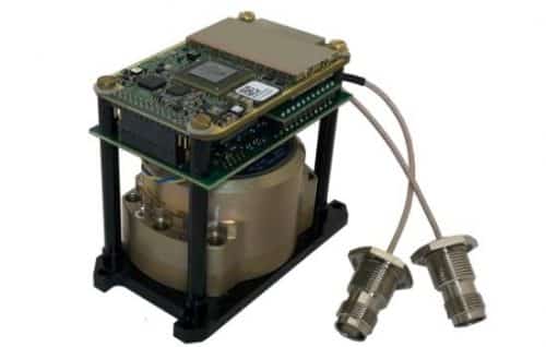
The GPS-Aided Inertial Navigation System (INS) is a fusion of inertial and GPS measurements allowing a highly precise GNSS signal. This unit is housed on the IP67, which makes it accurate even in the harshest environmental conditions. A GPS-aided INS determines the state of a vehicle or an object over which it is mounted such as its position, velocity and orientation.
With the latest technology of MEMS (Microelectromechanical System), the INS is more compact and light-weight, giving an expansion to the number of applications it can be used.
The GPS-Aided Inertial Navigation Unit consists of an Inertial Labs developed Tactical or Industrial-grade Inertial Measurement Units (IMU), a reliable single or dual GNSS receiver and embedded, high-precision, gyro-compensated magnetic compass.
The unit determines the calculations of orientation of an object using a computer, accelerometers (motion sensors) and gyroscopes (rotation sensors). Gyroscopes measure the angular velocity while accelerometers determine the linear acceleration with ease.
It is a low cost, highly robust unit with the ability to very accurately detect any change in the geographical position (heading) of the object on which it is mounted. With the inclusion of GPS in the INU, the unit provides the information at a much faster rate.
The INU finds its suitability in the industrial, commercial, aerospace, defence, military and agriculture sectors. The applications of Inertial Navigation Unit include Remotely Operated Vehicles (ROV), Autonomous Ground Vehicles (AGV), GPS-Denied Navigation for unmanned ground vehicles (UGV), Autonomous vehicles navigation, Unmanned Aerial Vehicles (UAV), Scanning & Mapping and Remote
-

Dual Antenna GPS-Aided Inertial Navigation Systems INS-DU
View Product -
Dual Antenna, GPS-Aided Inertial Navigation System : INS-DH-OEM
View Product -
Dual Antenna, GPS-Aided Inertial Navigation Systems INS-DU-OEM
View Product -
GPS-Aided Inertial Navigation Systems INS-U
View Product -
InertialLabs INS-B-OEM | OEM Version GPS-Aided Inertial Navigation System
View Product -
InertialLabs INS-D-OEM and INS-DL-OEM | Dual Antenna, GPS-Aided Inertial Navigation Systems
View Product -
Single and Dual Antenna GPS-Aided Inertial Navigation System – INS
View Product


The GPS-Aided Inertial Navigation System (INS) is a fusion of inertial and GPS measurements allowing a highly precise GNSS signal. This unit is housed on the IP67, which makes it accurate even in the harshest environmental conditions. A GPS-aided INS determines the state of a vehicle or an object over which it is mounted such as its position, velocity and orientation.
With the latest technology of MEMS (Microelectromechanical System), the INS is more compact and light-weight, giving an expansion to the number of applications it can be used.
The GPS-Aided Inertial Navigation Unit consists of an Inertial Labs developed Tactical or Industrial-grade Inertial Measurement Units (IMU), a reliable single or dual GNSS receiver and embedded, high-precision, gyro-compensated magnetic compass.
The unit determines the calculations of orientation of an object using a computer, accelerometers (motion sensors) and gyroscopes (rotation sensors). Gyroscopes measure the angular velocity while accelerometers determine the linear acceleration with ease.
It is a low cost, highly robust unit with the ability to very accurately detect any change in the geographical position (heading) of the object on which it is mounted. With the inclusion of GPS in the INU, the unit provides the information at a much faster rate.
The INU finds its suitability in the industrial, commercial, aerospace, defence, military and agriculture sectors. The applications of Inertial Navigation Unit include Remotely Operated Vehicles (ROV), Autonomous Ground Vehicles (AGV), GPS-Denied Navigation for unmanned ground vehicles (UGV), Autonomous vehicles navigation, Unmanned Aerial Vehicles (UAV), Scanning & Mapping and Remote